|
According to the National Hurricane Centre (NHC)
strengthening is forecast over the next two days however
Anguilla has fallen OUT of the 3 and 5 day cone areas.
Further Bulletins will not be issued unless the situation
changes. The Final Bulletin issued was Public Advisory
No. 3 - not posted to the website.
Department of Disaster Management Anguilla
Public Advisory No. 2
1:00pm Tuesday 2 September 2008
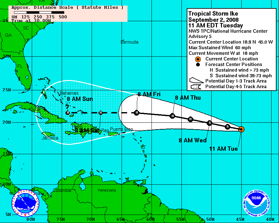
Anguilla is no longer in the five-day forecast envelope
for Tropical Storm IKE however we are still close to the
boundary.
According to the National Hurricane Centre (NHC) Tropical
Storm IKE will have some strengthening in the next two days.

The official forecast this afternoon from the National
Hurricane Centre is as follows:
...IKE STRENGTHENS A LITTLE OVER THE CENTRAL ATLANTIC...
AT 1100 AM AST...1500Z...THE CENTER OF TROPICAL STORM IKE
WAS
LOCATED NEAR LATITUDE 18.9 NORTH...LONGITUDE 45.0 WEST OR
ABOUT 1110
MILES...1785 KM...EAST OF THE LEEWARD ISLANDS.
IKE IS MOVING TOWARD THE WEST NEAR 18 MPH...30 KM/HR...AND
THIS
GENERAL MOTION IS EXPECTED TO CONTINUE DURING THE NEXT TWO
DAYS.
MAXIMUM SUSTAINED WINDS ARE NEAR 60 MPH...95 KM/HR...WITH
HIGHER
GUSTS. GRADUAL STRENGTHENING IS FORECAST DURING THE NEXT 48
HOURS
AND IKE COULD BECOME A HURRICANE ON WEDNESDAY.
TROPICAL STORM FORCE WINDS EXTEND OUTWARD UP TO 175
MILES...280 KM
FROM THE CENTER.
ESTIMATED MINIMUM CENTRAL PRESSURE IS 1002 MB...29.59
INCHES.
REPEATING THE 1100 AM AST POSITION...18.9 N...45.0 W.
MOVEMENT
TOWARD...WEST NEAR 18 MPH. MAXIMUM SUSTAINED WINDS...60 MPH.
MINIMUM CENTRAL PRESSURE...1002 MB.
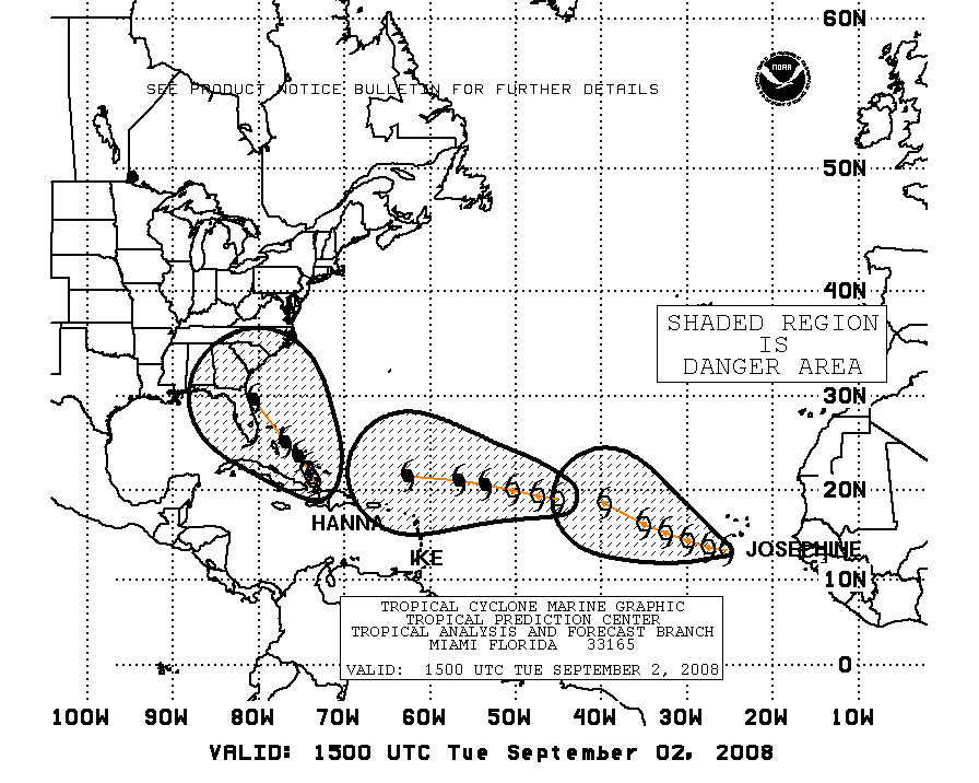
Boaters, fishermen and those living at or visiting the beach
need to monitor the storms progress and take precautions as
the storm nears. See below the Mariners 123 Chart for areas
defined as dangerous and note Anguilla is still in this
danger zone:
The National Disaster Management Committee will be convened
if and when Anguilla enters the 3-day or 72-hour forecast
area.
As a reminder, residents are encouraged to check their
preparations for the season including shutters, food
supplies, medicines and water. Please take time to clean up
yards and properties, remove old vehicles and appliances,
and strap down cooking gas tanks to reduce dangerous flying
debris in the event of a tropical storm or hurricane.
A further bulletin will be issued after the 2pm National
Hurricane Centre Update is received.
5 Day Cone Diagram Below, 3 day Cone in solid white:
Repeating:
The ninth depression of the season became Tropical Storm IKE
last evening and Anguilla is close to the boundary of the 5
day forecast envelope.
This means Anguilla could experience Tropical Storm or
Hurricane force conditions within the next 3-5 days however
as the storm formed closer to the Lesser Antilles, Anguilla
may soon enter the 3 day forecast envelope.
According to the National Hurricane Centre (NHC) some
strengthening is forecast in the next two days.
Boaters, fishermen and those living at or visiting the beach
need to monitor the storms progress, Mariners 123 chart and
take precautions if the storm nears.
Residents and visitors should listen to Radio Anguilla,
local radio stations and television stations for updates
Further Caribbean Basin News:
The tenth tropical depression of the season became Tropical
Storm Josephine this morning, at this time the Department of
Disaster Management is monitoring this storm closely.
Tropical Storm Hanna is producing heavy rains over the
southeastern Bahamas and
Hispaniola and a hurricane warning remains in effect for the
central Bahamas...the
Southeastern Bahamas...and the Turks and Caicos islands.
If you require additional information please call the
Department of Disaster Management on 497-2926 or 476- 3622
or 476-3623.
|